About
The primary objective of the Eco-hub project is to expand the role of citizen scientists in the realm of urban and rural stormwater innovation, monitoring and governance in the Chesapeake watershed. Engaging citizen scientists in the Chesapeake watershed has already been initiated for the production of regional environmental report cards to complement the Chesapeake Bay EcoCheck report card. The approach here will be to use mobile technologies to dramatically expand and enhance the citizen scientist engagement as applied to urban and rural stormwater management. The University of Maryland Center for Environmental Science has taken a lead role in formulating strategic partnerships with Chesapeake Riverkeeper/Waterkeeper groups (Mid-Atlantic Tributary Assessment Coalition; MTAC), NOAA (EcoCheck), Maryland State Government (BayStat; Maryland Trust Fund) and the Chesapeake Bay Program (Science and Technical Analysis and Reporting; ChesapeakeStat). Each of these partnerships will be used to facilitate citizen scientist involvement using mobile technologies, including a mobile application that will allow citizen scientists to upload and download data, images and training materials for their specific stormwater management sites. Two Riverkeeper groups will be on the project team to develop and beta-test the citizen scientist interfaces. Urban stormwater will be the focus of Blue Water Baltimore in the Inner Harbor of Baltimore. Rural stormwater will be the focus of the Chester River Association, a Riverkeeper group utilizing the ‘Chester Testers’ citizen scientist group. An Eco-hub system will target citizen scientist data gathering for a) Stormwater quality monitoring, b) Runoff control initiative mapping and c) Watercourse/stream mapping. The expected result of this expanded citizen science involvement will be to foster innovation in stormwater management approaches, monitor efficacy of different stormwater practices and develop better governance models for targeting stormwater treatment options. A highly qualified team of Science Integrators, Science Communicators, Riverkeepers, Citizen Scientists, Web and App Developers, Remote Sensing Scientists will develop and test mobile technologies.
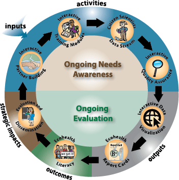 In order to illustrate how the project can develop a citizen scientists network and increase environmental literacy, the project is described in a logic map. The inputs, activities, outputs, outcomes, and strategic impacts are linked together in a recurrent circular set of tasks (Figure 1). The inputs and activities use an ongoing needs assessment to inform these tasks. The outputs, outcomes and strategic impacts utilize ongoing evaluation and enhancement to optimize effectiveness. There are eight activities in the logic map: interactive partner building, interactive training modules, citizen scientist data stream, interactive quality assurance, interactive data visualization, ecohealth report cards, environmental literacy, evaluation and dissemination. Each of these tasks is articulated below, but the major theme in the logic model is that the tasks are interconnected and employ needs assessment or evaluations.